


A Radio Map of the Columbia Broadcasting System (1935)
A map found through the Digital Library of America in the David Rumsey Map Collection

I’ve noted the Digital Public Library of America before in this blog, and today’s primary source archival find was located through that terrific resource. I searched and shuffled through NBC and CBS search results, and I located this fascinating “Radio Map of the Columbia Broadcasting System” in the David Rumsey Map Collection.
The image lists all the stations connected on the early CBS chain (this was only 8 years after CBS began in 1927 as United Independent Broadcasters (UIB) and did not extend past Omaha in its original incarnation).

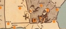
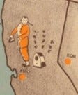
Of note - and you can’t really see this without zooming - is the amount of overt racism in these caricatures (cartoons) of radio listening in the United States in 1935. To our eyes in 2025, they seem like misguided and offensive attempts at celebrating the diversity of the American radio listening audience. In 1935, the artist was just having fun with promotional illustations to help advertisers visualize what a national radio network looks like in practice.
Here’s CBS listeners as represented in Georgia:
And here are the CBS listeners as represented in San Francisco:
Another interesting aspect of this map is the way it takes a national product for advertisers (a radio network, or “chain”) and localizes it. Listeners, on this map, are differentiated and made distinct by their geographic localities and local cultures, but they all share two things: A love of radio listening, and being located in the United States of America.
Here’s the interactive version of the map at the David Rumsey Digital Map Collection - check it out for yourself (for a sense of what Madison Avenue advertisers and radio network salesmen thought would be the most effective representation of audiences in the U.S.A. in 1935).